NDVI · Precision Agriculture · Conservation

Multispectral Imaging

Data across multiple wavelengths of light, far beyond what the human eye can see. Crop health, vegetation stress, moisture and land condition with extraordinary precision.

See your land in a new light

Data-driven decisions about your land.


Where thermal imaging detects heat, multispectral imaging detects crop health, vegetation stress, moisture variation and land condition with extraordinary precision. It captures data across multiple wavelengths of light, revealing patterns invisible to the naked eye.

Ideal for farmers, land managers, ecologists and conservation organisations looking to make data-driven decisions about their land. Every survey is delivered as a full report with annotated maps and clear analysis.
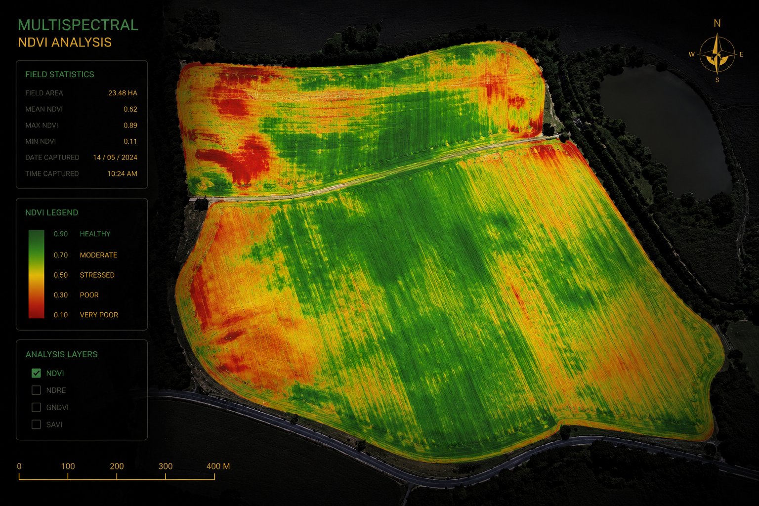
NDVI multispectral analysis map of farmland showing crop health zones in red, orange and green with field statistics

What multispectral imaging reveals.


Make data-driven decisions about your land, backed by precise, annotated survey data.

Why Land by Drone

Precision data. Professional judgement.


  • Class 1 Chief Engineer
  • 25+ years hands-on engineering experience
  • CAA regulated
  • Fully insured
  • Full written report with annotated maps
  • NDVI and multi-layer analysis
  • Recommendations you can act on
  • Devon, Cornwall and the wider South West
Common questions

Good to know.


NDVI (Normalised Difference Vegetation Index) measures plant health by analysing how vegetation reflects light. It reveals crop stress, disease and nutrient deficiency long before they are visible to the eye.

Farmers, land managers, agronomists, ecologists and conservation organisations, anyone who needs precise, data-driven insight into crop health, soil moisture or land condition.

Vegetation stress, disease, drought stress, nutrient deficiency, soil moisture variation and drainage patterns across an entire field, captured across multiple wavelengths of light invisible to the human eye.

As a full report with annotated maps and clear analysis, including NDVI and multi-layer data you can act on to make decisions about your land.

What our clients say

Proof in every report.

★★★★★ 5.0 from real Google reviews
★★★★★

"I recently used David to inspect a couple of problematic leaks in my son's house. He arrived within 24 hours of my call and flew the drone to inspect the whole roof and outside of the house. He successfully located the source of the leaks, provided photos and a report. He even climbed into the loft space to take photos so I was able to see clearly for myself. This saved a lot of time and money. I would thoroughly recommend without hesitation. Excellent service, knowledgeable and a very nice chap too!"

J
Julia Bowrey
via Google
★★★★★

"David came out within hours of my call and quickly identified the source of our roof leak. His expertise meant I knew exactly what the problem was and could get the right person in to fix it. No guesswork, no wasted time or money. His pricing was fair and he was professional throughout. Would definitely recommend."

R
Ryan Fox
via Google
★★★★★

"A thoroughly enjoyable process from enquiry through to delivery. End-to-end bespoke drone footage that best suited our marketing needs for our website and social media. Would highly recommend."

I
Iain White-Duncan
via Google
★★★★★

"Big thanks to David, helped us identify problems with an ongoing roof leak in a difficult to access area. Hopefully we can finally resolve this."

K
Kate Brookes
via Google
★★★★★

"Super professional, reliable and friendly service. Can't recommend enough."

C
Craig Sweett
via Google

Know your land before the season decides for you.

Book a multispectral survey. We respond to every enquiry within 24 hours, usually much sooner.

Get a Free Quote
Message us on WhatsApp