

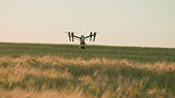

Survey-Grade Crop Health Data You Can Trust
Land by Drone provides multispectral drone surveys that reveal what is really happening in your fields. Using advanced NDVI and NDRE vegetation indices, we map crop health, pasture condition, soil stress and drainage issues across your land, delivering objective, measurable data that supports smarter decision-making around grazing, fertiliser application, reseeding and field management.
Unlike standard drone operators, every survey is led by a qualified engineer with over 25 years of technical and diagnostic experience. We do not just capture data. We interpret it, giving you a clear picture of what your land needs and where to focus your investment.
CAA Certified Pilots
£10M Public Liability Insurance
RTK/PPK Accuracy (±2cm)
24 to 48 Hour Turnaround
SERVICES


Built for Complex Projects
Speed
Survey large sites in hours, not days. Most data processed and delivered within 24 to 48 hours.
Safety
No scaffolding. No working at height. Our drones access hard-to-reach areas safely.
Accuracy
RTK-enabled drones with ground control deliver survey-grade precision within centimetres.
industries we serve
Agriculture
& Land Management
Crop health monitoring, irrigation assessment, yield prediction
Infrastructure
& Utilities
Bridge inspections, power line surveys, asset monitoring
Environmental
& Coastal Monitoring
Erosion tracking, habitat mapping, change detection
Quarries
& Aggregates
Stockpile volume calculations, haul road optimization
WIND
& SOLAR FARMS
Blade inspections, thermal panel analysis, site mapping
Construction
& Civil Engineering
Progress tracking, volumetric analysis, site mapping
Engineering Precision Meets Aerial Technology
Land By Drone is led by David Justin, a Class 1 Chief Engineer with 25+ years of maritime and mechanical engineering experience. We're not just drone operators—we're qualified engineers who understand structural integrity, mechanical systems, and technical diagnostics. Every survey benefits from CAA-certified piloting combined with professional engineering insight.